Marina Traffic and Road Conditions
Marina Traffic Map
How to use the Marina Traffic Map
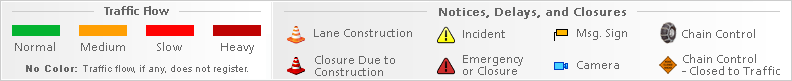
Traffic flow lines: Red lines = Heavy traffic flow, Yellow/Orange lines = Medium flow and Green = normal traffic or no traffic*. Black lines or No traffic flow lines could indicate a closed road, but in most cases it means that either there is not enough vehicle flow to register or traffic isn't monitored. Also, If you do not see traffic flow, you can zoom in closer to reveal localized data. If you are unable to pan the map, press here (to focus off of the map) and try again.
* In known extreme weather events or accidents, the map provider may still show green lines, even if lanes or the entire road is closed.
Traffic Alert

- Click or touch the map to move in different directions.
- If you do not see any markers on the map, try zooming in one or two levels using "+" on the top left side. However, they are not always available.
- Click an incident icon on the map to get more information.
Marina Traffic Alerts
Caltrans District 5 on Twitter
RT @CaltransDist7: *State Route 33 - Los Padres National Forest* SR-33 remains closed north of Ojai from Matilija Hot Springs Road to Lockw…
REMINDER: This closure is scheduled for TONIGHT. #SantaCruzCounty https://t.co/XAPoV2HVNe
The on and off-ramps to #Hwy1 from both directions of US 101 will be closed as well for the grinding and paving of… https://t.co/o89N3LYDdZ
This closure will allow for the grinding & paving of roughly six miles of US 101 in addition to the reconstruction… https://t.co/FkxTydsYFC
NEXT WEEK: A paving project on #Hwy101 from north of Gaviota State Park to Old Coast Highway in #Gaviota will begin… https://t.co/tEph42RbyY
RT @CA_Trans_Agency: 8/8 🔗https://t.co/sM7IqBS4TI
RT @CA_Trans_Agency: 7/ By maintaining key state investments & streamlining projects, CA continues to be in a great position to compete for…
RT @CA_Trans_Agency: 6/ I’m also thrilled to see @CAgovernor’s ambitious infrastructure permitting and project review reforms in the final…
CA DOT | Caltrans QuickMap | CHP Traffic Full Site | CHP Traffic Mobile Site
Currently
 |
55°F |
30.08in
Barometer 87%
Humidity West 5.8mph Wind |
| Overcast | ||