Palos Verdes Peninsula Traffic and Road Conditions
Palos Verdes Peninsula Traffic Map


How to use the Palos Verdes Peninsula Traffic Map
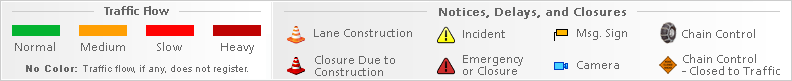
Traffic flow lines: Red/White dashed lines = Closed Road, Grey/White dashed lines = Road Work, Red lines = Heavy traffic flow, Yellow/Orange lines = Medium flow and Green = normal traffic. Black lines or No traffic flow lines could indicate a closed road, but in most cases it means that either there is not enough vehicle flow to register or traffic isn't monitored. Also, If you do not see traffic flow, you can zoom in closer to reveal localized data. If you are unable to pan the map, press here (to focus off of the map) and try again.
Traffic Incidents: Each icon represents a traffic event or incident such as road construction, closure (red circle with a white dash) or accident.
In known extreme weather events or accidents, the map may still show green lines, even if lanes or the entire road is closed.
- Click or touch the map to move in different directions.
- If you do not see any markers on the map, try zooming in one or two levels using "+" on the top left side. However, they are not always available.
- Click an incident icon on the map to get more information.
Palos Verdes Peninsula Traffic Alerts
CA DOT | Caltrans QuickMap | CHP Traffic Full Site | CHP Traffic Mobile Site
Currently
 |
65°F |
29.9 inHg.
Barometer 88%
Humidity SE 10.8 mph Wind |
| Partly Cloudy | ||